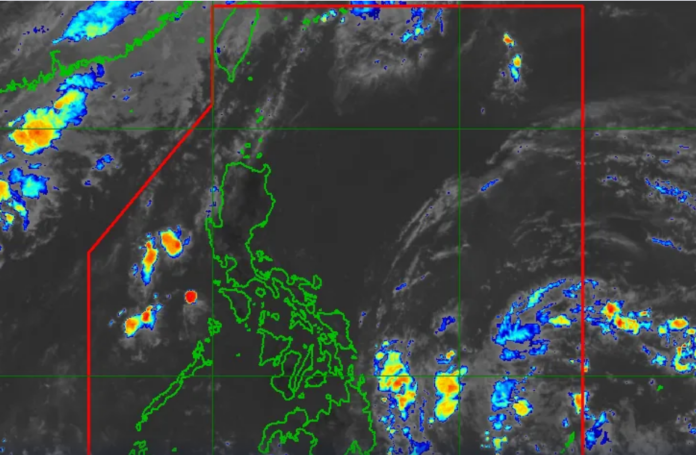
If the low-pressure area (LPA) east of the Philippines turns into a tropical depression on Friday, PAGASA may issue tropical cyclone wind alerts for Bicol and Eastern Visayas.
PAGASA weather specialist Ana Clauren-Jorda stated during a briefing on Thursday that the LPA, which is now 870 kilometers east of southeast Mindanao, is projected to deepen into a tropical depression within 24 hours.
It will be called Aghon when it strengthens into a tropical depression, making it the first storm of 2024 to hit the Philippines.
It is predicted that the weather disturbance will travel mostly northwest through Saturday before turning northeast on Sunday. It is expected to remain primarily offshore, close to Eastern Visayas and the Bicol region; on Saturday, it is expected to be closest to these regions.
“The possibility of the weather disturbance approaching Eastern Visayas and Bicol is not ruled out, so landfall in these areas is also possible,” she said in Filipino.
By Sunday, Aghon could become a tropical storm as it continues to strengthen over the Philippine Sea. By Tuesday, as it departs the Philippine Area of Responsibility, it may intensify even more into a powerful tropical storm.
Due to the weather disturbance’s widespread distribution, PAGASA stated that the anticipated trajectory may still alter and that there is still a great deal of uncertainty for the first 48 hours.
It is predicted that Surigao del Norte, Surigao del Sur, and the Dinagat Islands will see light to moderate rain today, with sporadic severe downpour. While light to moderate rain is possible across the Bicol region, the remainder of Caraga, and the rest of Eastern Visayas by Friday, moderate to heavy rain is possible over Eastern Samar and Northern Samar.
Along with light to moderate rain over Quezon province, which includes the Polillo Islands, the rest of the Bicol area, and the rest of Eastern Visayas, the potential cyclone might bring moderate to heavy rain, with sporadic intense rain, over Catanduanes, Camarines Sur, and Northern Mindanao.
Marcelino Villafuerte, the deputy administrator for research and development at PAGASA, stated, “[Aghon] could increase water levels, particularly in some dams where levels continue to drop. However, we also caution our fellow citizens because intense rains are expected in the coming days.”
Given the persistent heatwave in the area, PAGASA has already warned that the nation could see up to two tropical cyclones this month.


