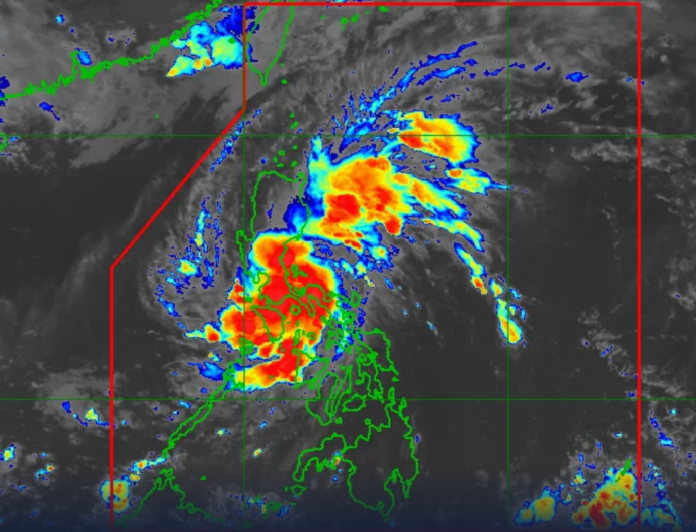
Typhoon Aghon (international name: Ewiniar) is still moving away from the Philippine landmass, and as of Monday morning, PAGASA has declared Wind Signal No. 2 for parts of eastern Luzon.
With peak winds of 140 kph in the center and gusts as high as 170 kph, the nation’s first cyclone of the year was last spotted over the coastal waters of Casiguran in Aurora. It is traveling at 10 kph toward the Philippine Sea from the north-northwest.
Over the following areas, the state weather agency issued wind alerts:
Signal No. 2: Expected winds of 62 to 88 kph in the next 24 hours
- Southeastern portion of Isabela (Dinapigue, Palanan)
- Northern portion of Aurora (Baler, Dipaculao, Dinalungan, Dilasag, Casiguran)
- Polillo Islands
Signal No. 1: (Intermittent rain or winds between 39 and 61 kph predicted within 36 hours)
- Northeastern and southern portions of Isabela (Divilacan, San Mariano, San Guillermo, Jones, Echague, San Agustin, Ilagan City, Benito Soliven, City of Cauayan, Maconacon, Angadanan, Naguilian)
- Eastern portion of Quirino (Maddela, Nagtipunan, Aglipay)
- Eastern portion of Nueva Vizcaya (Alfonso Castaneda, Dupax del Sur, Dupax del Norte)
- Rest of Aurora
- Eastern portion of Nueva Ecija (General Tinio, Gabaldon, Bongabon, Pantabangan, Rizal, General Mamerto Natividad, Laur, Palayan City, Peñaranda, San Leonardo, City of Gapan, Cabanatuan City, Santa Rosa, Llanera)
- Eastern portion of Bulacan (San Miguel, San Ildefonso, Doña Remedios Trinidad, Norzagaray)
- Rizal
- Northeastern portion of Laguna (Pakil, Mabitac, Pangil, Famy, Siniloan, Santa Maria, Paete, Kalayaan, Lumban)
- Northern and central portions of Quezon (General Nakar, Infanta, Real, Mauban, Perez, Alabat, Quezon, Calauag, Tagkawayan, Guinayangan, Lopez, Atimonan, Gumaca, Plaridel)
- Western portion of Camarines Norte (Santa Elena, Vinzons, Labo, Capalonga, Paracale, Talisay, Jose Panganiban, San Vicente, Daet) including Calaguas Islands
Strong winds may have little or no effect on the residents of these locations.
The National Disaster Risk Reduction and Management Council said on Sunday that a falling tree had harmed four individuals. The typhoon has affected more than 2,700 people.
Aghon is expected to dump 50 to 100 millimeters of rain to the eastern part of Isabela and the northern part of Aurora today, according to PAGASA. More rain was predicted in mountainous areas, with the potential to cause landslides and flooding, particularly in high-risk locations and areas that have recently seen a lot of rain.
The coastal waters of southern Cagayan, Isabela, Aurora, and the northern coastal seas of Quezon province, including the Polillo Islands, are dangerous for small seacraft travel, including any motor bancas, because of Aghon. Over the eastern coastal waters of Cagayan and the northern coastal waters of the Bicol area, the storm is expected to generate moderate to rough seas (1.5 to 3 meters).
As Aghon continues northeastward across the Philippine Sea over the following two days, the meteorological bureau says it will only get stronger. By Wednesday afternoon or evening, it might become a typhoon and leave the Philippine Area of Responsibility (PAR).
Forecast Positions:
- May 27, 2024 5:00 p.m.: 200 km east of Tuguegarao City, Cagayan
- May 28, 2024 5:00 a.m.: 1,150 km north-northeast of Extreme Northern Luzon (outside PAR)
- May 28, 2024 5:00 p.m.: 620 km east of Itbayat, Batanes
- May 29, 2024 5:00 a.m.: 950 km east-northeast of Extreme Northern Luzon
- May 29, 2024 5:00 p.m.: 1,280 km east-northeast of Extreme Northern Luzon (outside PAR)
- May 30, 2024 5:00 a.m.: 1,655 km east-northeast of Extreme Northern Luzon (outside PAR)


